|
HISTORY OF MEXICO |
|||||||
|
An educational project of the Houston Institute for Culture |
|||||||
|
THE HISTORY OF HIDALGO By John P. Schmal The central Mexican state of Hidalgo has a surface area of 20,860 square kilometers (8,054 square miles), or 1.05% of the national territory. Located in Mexico's Central Plateau, Hidalgo is the twenty-sixth largest state of Mexico. With a population of about 1,888,366 inhabitants (in 1990), Hidalgo shares common borders with San Luis Potosí on the north, Puebla on the east, Tlaxcala on the southeast, the state of Mexico on the south, Querétaro on the west, and Veracruz on the northeast.
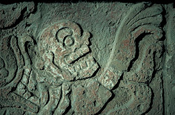
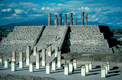
The capital of Hidalgo is Pachuca, which is located 94 kilometers (60 miles) from Mexico City. Pachuca's name was derived from the term Patiachiucan, which in the Náhuatl language means "narrow place." The city was founded in the year 1488 and through its history it has always been linked to mining. It was here where, in 1553, Bartolomé de Medina, invented the system of amalgamation for mining silver. Pachuca, which continues to be an important mining center today, has been nicknamed La Bella Airosa (The Windy City) because during most of the year there are strong northeastern winds that can reach up to 75 kilometers per hour. In pre-Hispanic times, a wide range of indigenous tribes, including the Otomíes, Tepehuanes, Mexica, and Nahua, inhabited various parts of the present-day state of Hidalgo. In the Fifteenth and Sixteenth Centuries, Hidalgo was conquered by the Mexica and incorporated into the Aztec Empire. In fact, the present-day state of Hidalgo was occupied by several Aztec provinces: Axocopan, Atotonilco, Xilotepec, and Chiapan. The province of Axocopan was located north of the Valley of Mexico in the cold, dry plateau area known as the Valley of Mezquital. This region was primarily occupied by Otomí Indians, and a lesser number of Pame Indians (who belonged to the Chichimec Indians). Axocopan was conquered by Mexica emperor, Moctezuma Ilhuicamina, who ruled over the Aztec Empire from 1440 to 1464. The primary crops grown in this region were maguey and nopal. The province of Atotonilco was located immediately north of the Valley of Mexico and was primarily occupied by Otomí and Mazahua Indians. This area, in which maguey and nopal were the primary crops, was also conquered by Moctezuma Ilhuicamina. The Mexica recognized the Otomíes as expert farmers and hunters and required tribute from them in the form of foodstuffs. The Aztec province of Xilotepec was originally part of an Otomí kingdom located in the frontier area between the central Mexican Nahua-speaking Indians and the Chichimec Indians of the north and northwest. With an area of more than 4,000 square kilometers, Xilotepec was one of the largest provinces of the Aztec Empire and contained at least 47 towns. Although the Otomí put up a fierce resistance, Xilotepec was eventually captured. In order to fortify the area against Chichimeca incursions, the Mexica maintained garrisons in the city of Xilotepec and smaller frontier towns. The town of Tula (Tollan), located on the outskirts of Tula de Allende in Hidalgo, some 55 miles (90 kilometers) north of Mexico City, was the site of one of the greatest civilizations in Mexican history: the Toltecs. Tula was called Namenhí (Place of Many People) by the Otomí Indians. It is believed that Tula existed as a center of Toltec civilization for more than four centuries until it was abandoned in 1156. Boasting cultural elements from diverse sources, Tula became an important spiritual center and is now recognized as an important archaeological zone. An agricultural crisis triggered Tula's decline, which culminated in its capture by marauding Otomíes and Chichimeca Indians.
Tula was eventually conquered by the Mexica and became a strategic part of the Aztec province of Chiapan. Lying between Axocopan, Atotonilco and Xilotepec, the region was known as Teotlalpan. The ruins of Tula became an important pilgrimage center for the Mexica, although the region had to be subdued several times. The regional economy was dependent upon maguey production, as well as lime and wood. In 1520, Captain-General Hernán Cortés was the first European to cross through the territory of Hidalgo, as he led his campaign against Tenochtitlán, the home of the Mexica and the capital of the Aztec Empire. By the spring of 1521, the Spaniards gained control of this area. Sometime around 1530, Franciscan missionaries began their spiritual conquest of the Indians in this region. During colonial times, mining was the most important economic activity of the Hidalgo. However, the mining activity, so vital to Hidalgo's economy, came to abrupt halt in 1810 during the War of Independence against Spain. Many of the mines were closed down, while the miners took refuge. Hidalgo was part of the state of Mexico until it received the status of state on January 15, 1869. Hidalgo's proximity to Mexico City has given the region a significant level of industrial development in recent decades. Today, the State of Hidalgo is home to six major industries: mining, textiles, food, auto parts, metal mechanics and oil. Hidalgo is fast becoming one of Mexico's most important industrial centers for the assembly of public transport vehicles, including subway and railroad cars, heavy machinery, automobiles and trucks. Manufacturing makes up 24.36% of Hidalgo's gross domestic product. The region of Tula is a significant producer of lime and cement and is also the site of an important petrochemicals complex. Some of the main enterprises operating in Hidalgo are Windsor Bicycles, Carnival, Coca-Cola, Sara Lee, and Playtex. Other components of Hidalgos' economic activity include mining (1.6%), construction (5.18%), trade (12.01%), and transports and communications (7.41%). But, agriculture and livestock also play a key role in Hidalgo's economy, contributing to 10.01% of Hidalgo's gross domestic product. Hidalgo has become Mexico's leading producer of barley, corn, beans, tomatoes, coffee, and alfalfa, peaches and apples. In addition, cattle raising has made the state a principal supplier of meat and dairy products for Mexico City. Copyright © 2004 by John P. Schmal. All Rights Reserved. Read more articles by John Schmal. Sources: Michael E. Smith and Frances F. Berdan, "Province Descriptions" in Frances F. Berdan et al., Aztec Imperial Strategies (Wash, D.C.: Dumbarton Oaks Research Library & Collection, 1996), pp. 265-349. John Schmal is an historian, genealogist, and lecturer. With his friend Donna Morales, he coauthored "Mexican-American Genealogical Research: Following the Paper Trail to Mexico" (Heritage Books, 2002) and "The Dominguez Family: A Mexican-American Journey" (Heritage Books, 2004). He has degrees in History (Loyola-Marymount University) and Geography (St. Cloud State University) and is a board member of the Society of Hispanic Historical Ancestral Research (SHHAR). He is an associate editor of SHHAR's online monthly newsletter, www.somosprimos.com. John is presently collaborating with illustrator Eddie Martinez on a manuscript entitled "Indigenous Mexico: Past and Present." | |||||||
| STATE HISTORIES TRADITIONS OF MEXICO SEARCH HOUSTON INSTITUTE FOR CULTURE |